About the Route
The Cilicia Road invites you on unforgettable journeys through mesmerizing natural scenery, ancient water systems, and timeless ruins. Beginning in the northern stretches of the Lamos (Limonlu) Valley and extending upstream toward the river’s source, these walking trails pass alongside Roman aqueducts and impressive feats of ancient engineering. Deep canyon paths offer a tranquil, immersive nature experience, while the routes from Kızılgeçit to Sömek unveil Roman water channels and striking soldier reliefs carved into the rock.
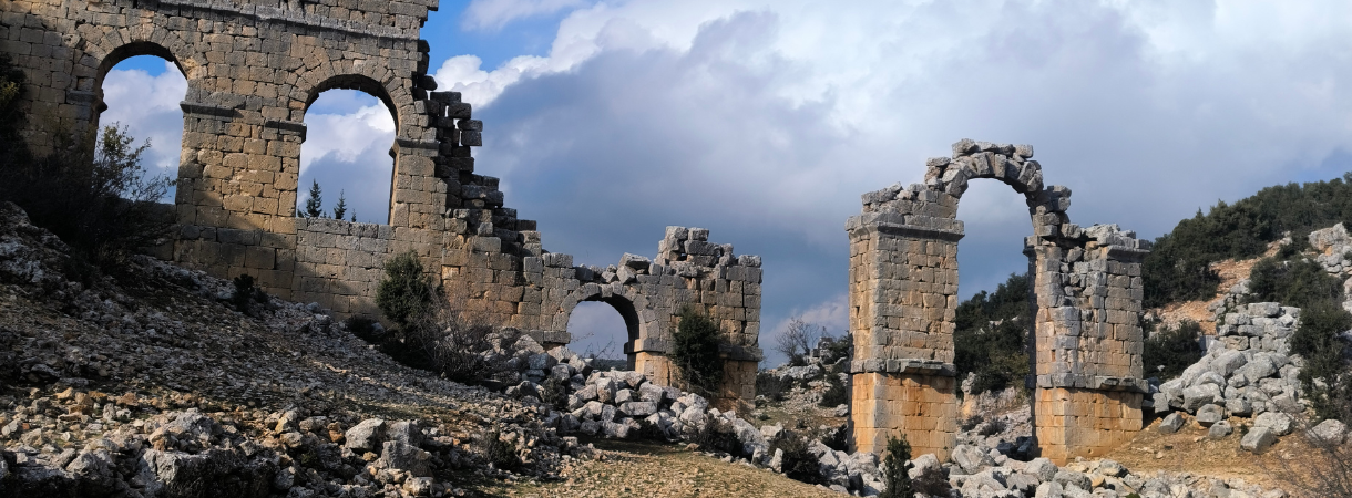
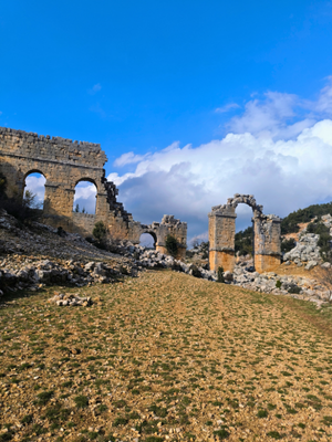
Upon reaching the southern part of Limonlu Valley, visitors encounter an ancient Roman bridge, a church, and the remains of an old water mill. The road continuing from Somek towards İmirzeli and Catıoren offers the opportunity to explore remains from the Hellenistic, Roman, and Byzantine periods. The Kerykeion symbol at the entrance to the Temple of Hermes highlights the origins of the healthcare sector. In Cambazlı Village, Roman monumental tombs and Byzantine churches form an impressive landscape. The road from here to the ancient city of Olba displays the splendor of the ancient capital with its aqueducts and theater ruins.
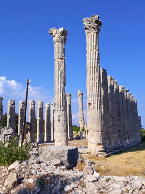
The sacred road between Olba and Uzuncaburç (Diocaesarea) offers the opportunity to visit the Roman-era pilgrimage center by reaching the Temple of Zeus. The walk toward Keşlitürkmenli unfolds like a journey through time, featuring Byzantine-era farmsteads, Hellenistic-Roman outposts, and the striking relief of Jupiter Dolichenus. Winding through forest paths, the route leads to archaeological treasures such as Yenibahçe and Kümbetkale, where the enduring legacy of ancient cities can still be felt.
The route to Atakent offers the opportunity to discover the impressive nature of the canyons, while the Cennet Cehennem (Heaven-Hell Sinkhole), Akkum, and Kızkalesi route is one of the richest walking trails in terms of cultural heritage. The path from Korykos to Adamkayalar offers a chance to witness some of Anatolia’s most impressive rock reliefs, as the route extending from Kızkalesi (Maiden's Castle) toward Elaiussa Sebaste and Kanlıdivane (Kanytella) blends history and nature through ancient necropolises, seaside churches, and sacred archaeological sites.
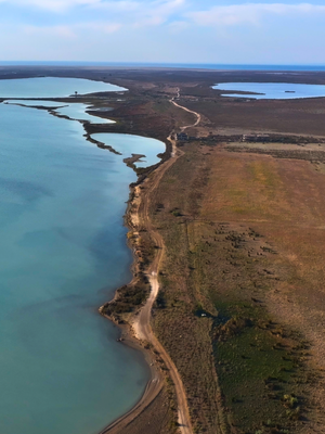
Upon reaching Demircili (Imbriogon), you will encounter impressive temple tombs. From here, the walk to Silifke continues with Roman and Hellenistic period ruins. When you head south from Silifke, the Dalyan (Paradeniz—semi-sea) region offers an unforgettable experience with its bird sanctuary and stunning natural beauty.
Route Features


Route Details
Route Stages
Gökler Creek – Sarıaydın – Aksıfat
It is the first of the 16 interlinked trails known as the Olba Trails. It is the northernmost trail in the Lamos (Limonlu) Valley. As in ancient times, the Lamos (Limonlu) River continues to supply water to a wide region. On this magnificent trail, you’ll head north from Gökler Creek on a journey to the river’s source. It is a moderate-level path, about 18 km long, and offers plenty of opportunities for swimming.

Gökler Creek – Kızılgeçit
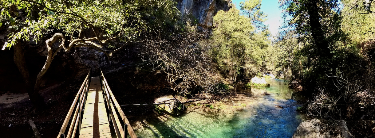
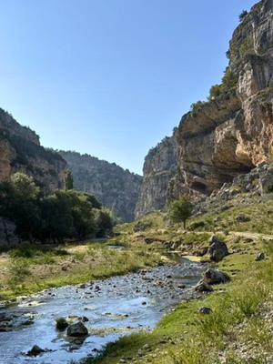
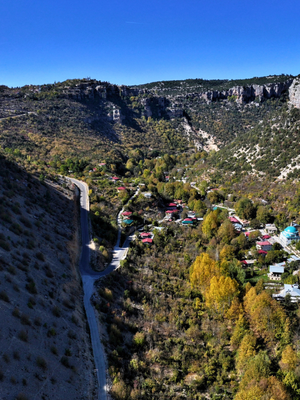
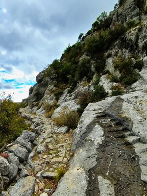
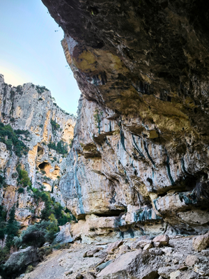
Set in one of Türkiye’s most stunning canyons—Lamos—this enchanting trail winds south along the serene banks of the Lamos (Limonlu) River. As you follow the river’s course, you’ll be immersed in the canyon’s breathtaking scenery and soothed by the sound of flowing water. This route offers a peaceful escape into nature and stands out as one of the most picturesque sections of the Cilicia Road.
Kızılgeçit–Sömek
As the second of three remarkable routes in the Lamos (Limonlu) Valley, this scenic trail follows the river south from Kızılgeçit, offering a balanced combination of nature and history. Along the valley’s western slope, hikers can observe ancient Roman water channels carved into the rock—an impressive engineering achievement designed to transport water from Kızılgeçit and its northern springs to coastal settlements through a gravity-fed system. Constructed with a precise gradient of just 2‰ over long distances, these channels highlight the sophistication of Roman infrastructure.
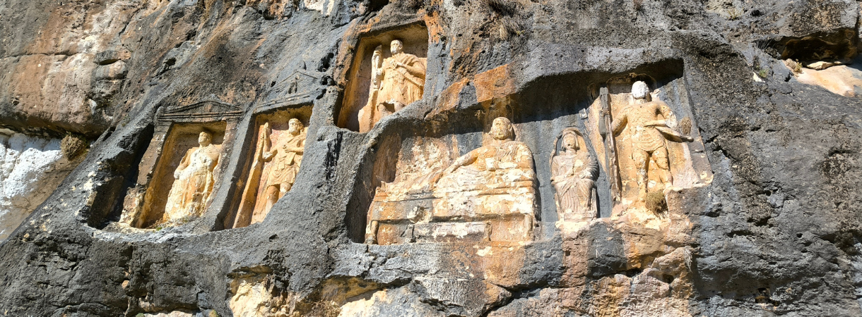
As the trail exits the valley and approaches Sömek Village, visitors encounter significant cultural landmarks: around 1 km ahead, a Roman-era soldier relief stands along the route, followed 500 meters later by a rare early 3rd-century AD relief of the goddess Athena, positioned just east of the main trail. This representation of Athena is a unique artifact in all of Anatolia. Covering an easy 16.4 km, the route invites both nature lovers and history enthusiasts to explore landscapes shaped by time and legend. The 4-kilometer section between Sömek Village and Lamos Canyon is paved, making it accessible by vehicle.
.
Sömek -İmirzeli- Çatıören
Beginning in the village of Sömek, this captivating trail follows the course of an ancient Roman road—one of many in the Olba region that connects a network of long-forgotten settlements. Hikers will encounter remarkable traces of antiquity, offering a journey through layers of Hellenistic, Roman, and Byzantine history.
The route features two outstanding archaeological treasures: İmirzeli and Çatıören. These ancient settlements, still largely unexcavated, showcase impressive architectural remains and invite discovery. One of the highlights of the trail is the chance to photograph the Temple of Hermes in Çatıören—an exceptionally well-preserved 2nd-century BC structure. Above its monumental entrance, visitors can admire two reliefs of the Caduceus (Kerykeion), Hermes’ staff with intertwined serpents—an enduring symbol now widely recognized in the health and medical fields. This is a must-see for cultural explorers and archaeology enthusiasts.
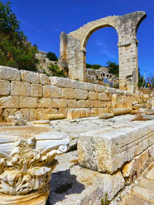
Sömek–Cambazlı–Olba
Once a vital crossroads in antiquity, Sömek Village connects to Cambazlı via an ancient stone-paved road rich in history and natural beauty.
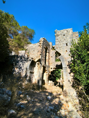
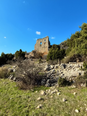
This scenic route leads to Cambazlı, a treasure trove of archaeological heritage featuring a splendid 2nd-century AD tomb and a beautifully preserved 5th-century church, both among the most remarkable monuments in Anatolia.
After exploring Cambazlı, where photo opportunities abound, the path continues toward Olba, the sacred capital of the Olba Priest Kingdom, through the lush Karyağdı Valley.
This section follows a remarkably preserved Roman road, culminating in the impressive ruins of Olba, highlighted by its majestic aqueduct.
Spanning this offers a perfect blend of history, nature, and architectural splendor.
Olba–Sumakalanı–Keşlitürkmenli (Eastern Road):
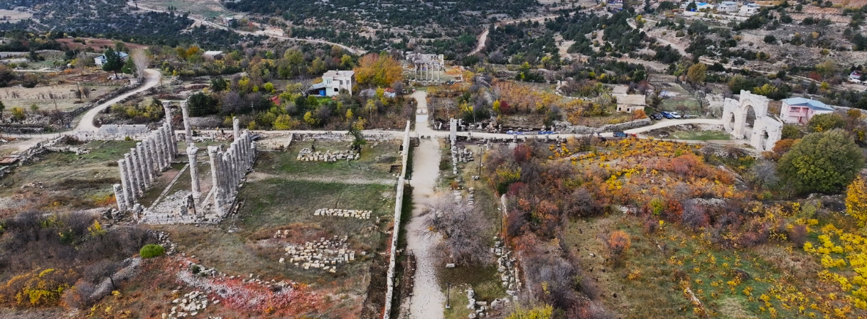
Olba is the ancient capital of the Olba Region from the Hellenistic period. However, all of the monumental structures encountered in Olba today, such as the aqueduct, theater, city walls, tombs, and nymphaeum, date back to the Roman period.
After capturing the impressive archaeological beauty of the capital, you will reach Sumakalanı and Keşlitürkmenli via a wonderful Roman road paved with stones. It is a of
Olba- Diocaesarea- Sumakalanı – Keşlitürkmenli (Western Road)
Stretching for approximately 4 kilometers, the ancient sacred road connects the former capital, Olba, to the sacred site of Uzuncaburç, which was once a major pilgrimage destination.
Beginning at Olba’s western gate, this stone-paved road leads to the grand Temple of Zeus, marking the heart of a spiritual and ceremonial center in antiquity.
During the Roman period, this sacred area was separated from Olba and reestablished as Diocaesarea, the new capital of the Olba Region.
Along this unforgettable path, visitors can walk on original Roman paving stones, explore both historic capitals, and admire stunning archaeological landmarks.
Continuing toward Sumakalanı and Keşlitürkmenli, is of and a true delight for history and archaeology enthusiasts.
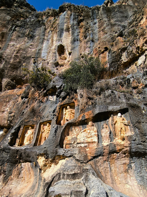
Keşlitürkmenli - İmamlı – Yenibahçe
This scenic path begins with a peaceful forest walk and leads to Gökkale, a remarkably preserved Byzantine farmhouse. The path then continues to İmamlı, once home to a significant outpost of the Olba Priest Dynasty during the Hellenistic period. From there, it descends toward Yenibahçe Stream, partially following ancient Roman roads through landscapes rich in history. Along the way, hikers encounter a wealth of archaeological treasures, including the impressive Gökkale, a 5th-century AD Byzantine villa rustica (large farmhouse). Notable highlights also include the hilltop ruins of Meydankale, a Hellenistic-Roman fortress, and a striking relief of Jupiter Dolichenus standing on the back of a bull. This captivating offers a and a deep dive into the region’s layered past.
Yenibahçe -Kümbetkale- Kabasakallı
Yenibahçe, a major crossroads of the Cilicia Road, serves as a vital artery in the Olba Region’s ancient trail network.
From this key junction, several paths branch out, including the southeast route leading to remarkable archaeological sites.
Highlights along this stretch include the Roman or Hellenistic-Roman fortress of Kümbetkale, the mysterious Aşağı Dünya Obruğu (Lower World Sinkhole), Karakabaklı, and the castles of Sinekkale and Işıkkale. The trail concludes at Kabasakallı Village, just 4 km east of Silifke. The path is . It is recommended to start the path by driving the first 4-kilometer paved section from Kabasakal Neighborhood.
Yenibahçe – Atakent (Kubat Canyon)
This offers a route through one of the most stunning canyons along the Cilicia Road.
Kubat Canyon is not only visually breathtaking but also historically significant as part of the ancient connection between the inland capital of Olba and the Mediterranean coast.
Following a path carved through time, this valley stands as a remarkable example of how natural landscapes once served as vital transportation corridors. The journey concludes in the seaside town of Atakent.
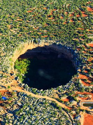
Yenibahçe-Tekkadın-Mezgitkale-Hasanaliler-Cennet Cehennem-Akkum-Kızkalesi
This route, which follows the Cilicia Road, is one of the most culturally rich paths, if not the most. All the towns listed above have archaeological sites, each offering stunning views and historical stories. Kızkalesi (Maiden's Castle) can be reached via a beautiful road. . When you go south from Cennet Cehennem (Heaven - Hell Sinkhole), you'll arrive at Narlıkuyu in about 2 km. Don't miss seeing the three beauties (aka three graces) on the floor mosaic of the ancient bathhouse here. Due to the Mersin–Taşucu Highway construction project, Stage 27—Yenibahçe–Tekkadın–Mezgitkale–Hasanaliler–Cennet-Cehennem–Akkum–Kızkalesi—will be temporarily inaccessible to hikers.
Korykos (Kızkalesi) – Adamkayalar
Begin your journey from the heart of Kızkalesi, following an route that winds north along the eastern slope of the valley. This scenic path leads to Adamkayalar, one of Anatolia’s most striking cultural landmarks.
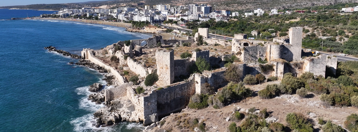
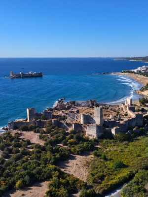
Kızkalesi (Maiden's Castle), known in antiquity as Korykos, is a symbol of Mersin, located about 60 km west of the city center.
The town’s name, “Maiden’s Castle,” comes from the offshore island fortress built in the Middle Ages, which is surrounded by legend.
According to local folklore, a prophecy warned a king that his daughter would be killed by a snake, prompting him to build the castle on the island to protect her.
Despite his efforts, a snake hidden in a basket of grapes found its way to the island, fulfilling the prophecy and giving the Korykos Castle its hauntingly beautiful and modern name.
Korykos (Kızkalesi) – Elaiussa Sebaste – Kanlıdivane (Kanytella)
This path, which connects the major archaeological sites on the coast, is one of the most important cultural routes of the Cilicia Road. Starting from the hidden necropolis of Korykos (Kızkalesi), the path passes through one of the most crowded cemetery areas in Anatolia and then reveals churches in magnificent condition. Accompanied by sea views, the path continues towards another important ancient city, Elaiussa Sebaste (Ayaş). After exploring the awe-inspiring ruins of Elaiussa Sebaste, once a thriving capital of the region, the trail leads through a significant ancient necropolis. From there, the path continues toward Çanakçı and Kanlıdivane, both of which were prominent sacred sites in antiquity.
Spanning , this challenging route offers a rich blend of cultural heritage and natural beauty.
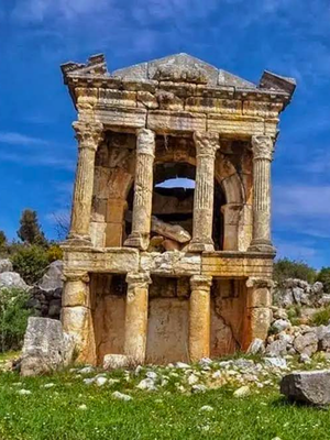
Yenibahçe – Demircili (Imbriogon)
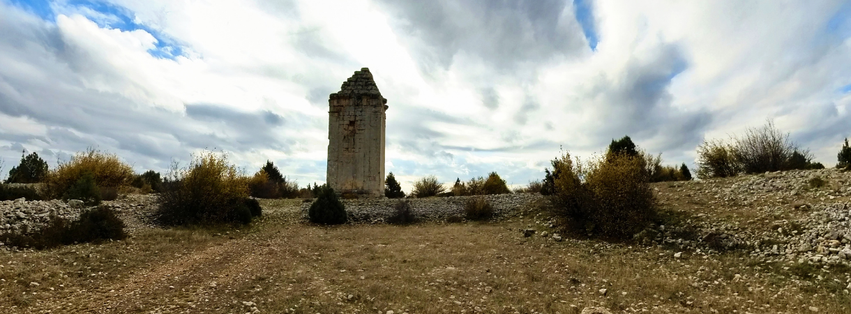
Heading southwest from Yenibahçe, one of the key crossroads of the Cilicia Road, this easy 10.6 km path leads to the monumental tombs of Demircili, considered among the most striking architectural remnants in the region.
Blending gentle terrain with historical splendor, the path offers an unforgettable journey through the heart of ancient Imbriogon, where stone speaks of legacy and landscape.
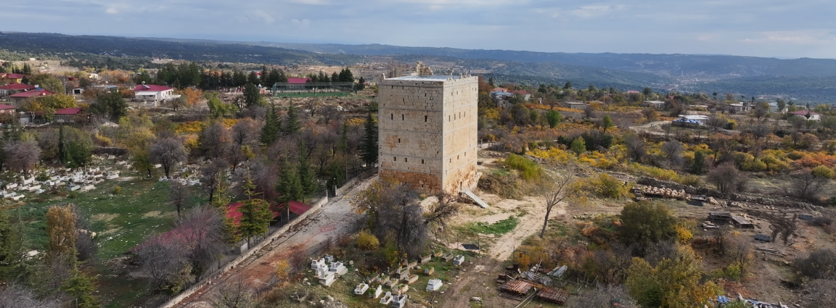
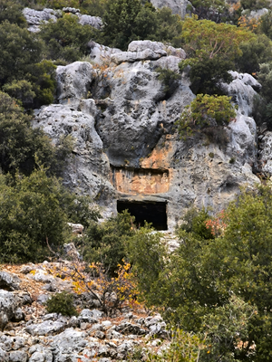
After visiting the stunning temple tombs of Demircili (Imbriogon), an easy 8.5 km walk takes you straight to the center of Silifke. Although Demircili contains remains from different historical periods, the most remarkable structures are the temple tombs. In this area, five monumental tombs are situated relatively close to one another, with two located on the left side of the main road and three on the right. In addition, the pyramid-roofed tomb slightly further east, at the site known as the Castle of Horozkale or Öterkale, can also be regarded as part of the same group.
Silifke Centre – Kurtuluş Village – Dalyan (Paradeniz)
An walk south of Silifke leads to Dalyan, also known as Paradeniz. This natural wonder is a bird sanctuary hosting around 400 species. During migration periods, visitors can observe large flocks of birds or, with some luck, spot endemic species." As one of the region’s main highlights, this path captivates with breathtaking views of Paradeniz and the vibrant colors of the protected delta, offering an unforgettable visual experience." The 11.5-kilometer stretch between Silifke and Dalyan is paved and used as a road for vehicles. For this reason, it is recommended to cover this 11.5-kilometer section by car and begin the hike from Dalyan. From the Dalyan fishing shelters, a 3.5-kilometer walk leads to the point where the Göksu River meets the sea, followed by a 3.5-kilometer return—making a total of 7 kilometers—after which the Dalyan Göksu Delta Taşucu trail is recommended for hiking.
PS: Paradeniz (literally "semi sea") is a lagoon along the Mediterranean Sea shore in Mersin. It is part of a lagoon system composed of four lakes.
.