About the Route
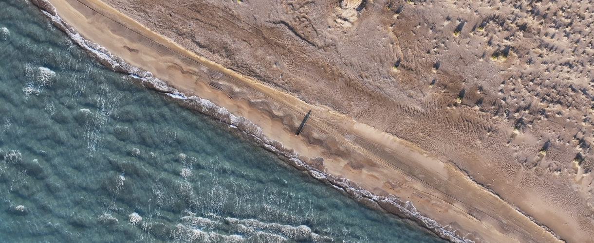
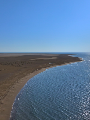
Beginning at the coast of Dalyan (Paradeniz) and stretching to İncekum Point, this unique walking route runs mostly along the shoreline and sandy terrain, offering a rare hiking experience with breathtaking views of the Göksu Delta, which has been shaped over millennia by the river’s alluvium. While the scenery is unforgettable, the combination of sea salt, sun, and lack of shade or water sources makes it a challenging path in hot weather. Summer hikes are not recommended, and campers should come well-prepared.
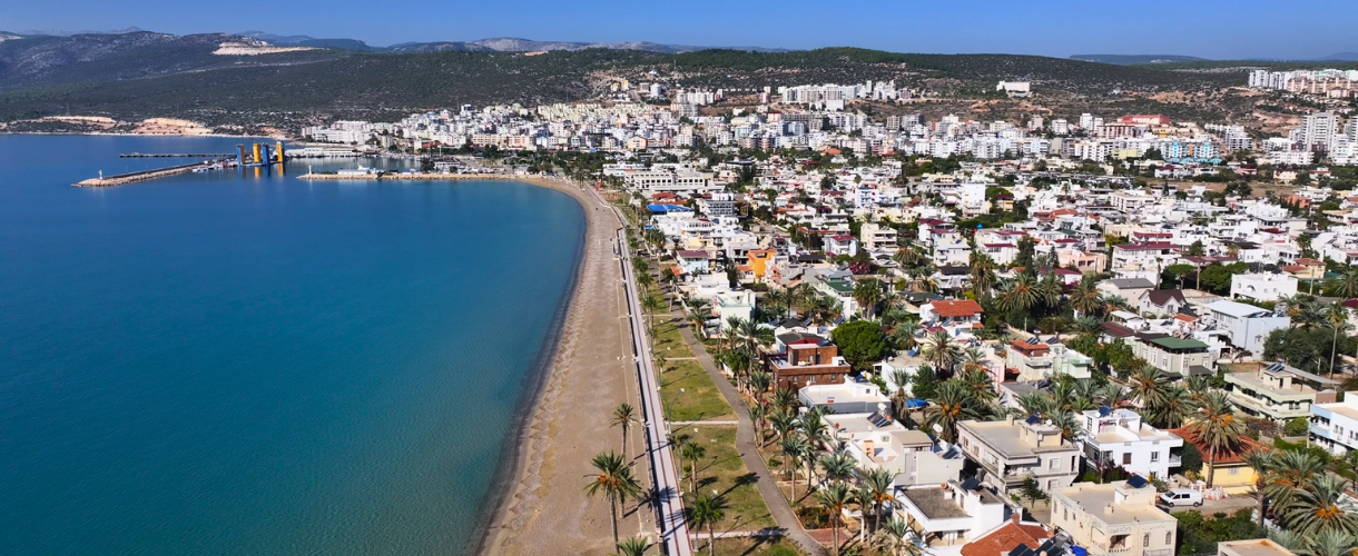
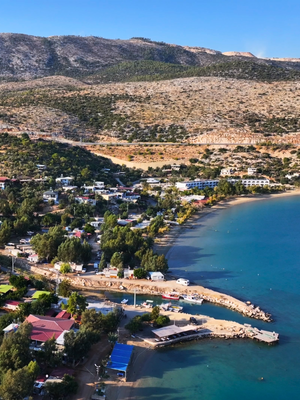
The route stretching from İncekum Burnu to Taşucu also has similar conditions. This approximately 10-kilometer road can become challenging for hikers in hot weather. Taşucu is a charming coastal town located 85 kilometers from Mersin and 10 kilometers from Silifke. Today, this port town is renowned for its fishing and tourism and serves as the departure point for ferries to Cyprus. The ‘Arslan Eyce’ Amphora Museum displays numerous amphorae recovered from shipwrecks in the region and caught in fishermen's nets. The Mermaid statue on the beach is also worth seeing.
The ancient city of Holmi, dating back to the 7th century BC, became the port of Seleukeia when its people were resettled in Silifke during the reign of Seleucus I Nicator. This port, which retained its importance until the Byzantine period, attracted attention not only for trade but also as a pilgrimage center for the Church of Saint Thecla during the Christian era.
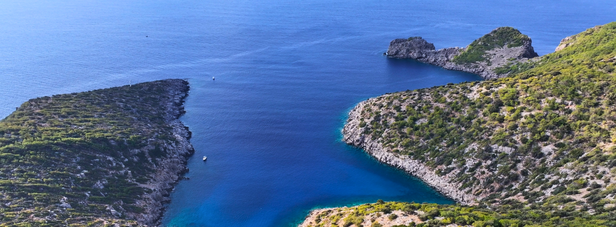
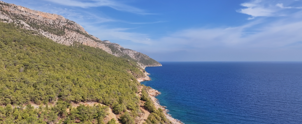
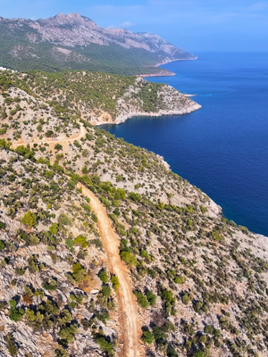
The walking route stretching from Taşucu to Eğribük (Barbaros) Bay is a path surrounded by the natural beauty of the Mediterranean. The coastline, with its changing colors, bays, and beaches, unfolds like a painting throughout the walk. Passing through the ruins of the ancient city of Holmi, the route leads to Akçakıl, the Liman Castle, which serves as a NATO naval base, and the stunning Boğsak Bay. This route, which also offers views of Boğsak Island, ultimately leads to Eğribük (Barbaros) Bay, providing hikers with an unforgettable Mediterranean view.
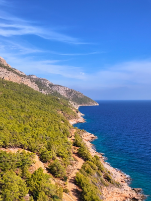
The path from Eğribük Bay to Mavikent offers hikers a visual feast amid natural beauty. This moderate difficulty route, approximately 12 kilometers long, provides an enjoyable walk accompanied by unique views of the Mediterranean Sea.
The path stretching from Mavikent to Cilicia Afrodisias, opposite Dana Island, offers a route surrounded by pine forests and adorned with the blue of the Mediterranean Sea. This easy walking path is 8 kilometers long.
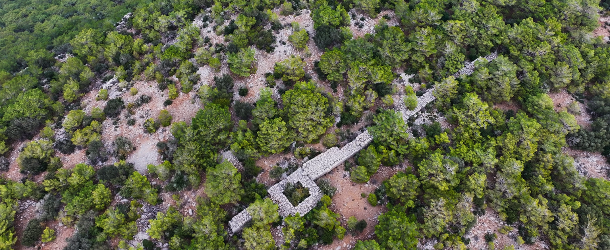
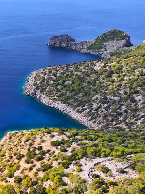
The route along the Tisan Peninsula winds its way through the ruins of the ancient city of Aphrodisias, surrounded by the blue, indigo, and turquoise tones of the Mediterranean Sea. This path, which occasionally passes through wooded areas and provides various views, is about 11 kilometers long. Although the ancient city has not been excavated, hikers have the opportunity to explore the traces of history by walking alongside the magnificent city walls and towers built in the 5th or 4th century BC.

Route Features


Route Details
Route Stages
Dalyan (Paradeniz) – Göksu Delta - Taşucu
It is one of those rare trails where much of the route follows the coastline and sandy terrain, yet creates an almost desert-like atmosphere. Walking this trail is not recommended, particularly in hot weather. Along this route, which continues from the shores of Dalyan (Paradeniz) in the Göksu Delta, visitors may choose to walk to the southernmost point of İncekum Point before rejoining the main trail. Flowing through the Taurus Mountains and enriching the land along its course, the river meets the sea where it forms the vast 15,000-hectare Göksu Delta. This 16.05-kilometer hike offers impressive views of loggerhead sea turtles, blue crabs, and rare bird species.
Situated 85 km southwest of Mersin and 10 km southwest of Silifke, this charming Mediterranean coastal district is now largely centered on fishing and tourism. Ferries to Cyprus depart from here. The “Arslan Eyce” Amphora Museum exhibits numerous amphorae recovered from nearby shipwrecks caught in fishermen’s nets, while the Mermaid statue along the coastline stands out as a notable landmark.
Known in antiquity as Holmoi, Taşucu is believed to have been established as a city in the 7th century BCE. The ancient geographer Strabo notes that during the foundation of Seleukeia (Silifke), Seleucus I Nicator (312–281 BCE) relocated the inhabitants of Holmoi to Seleukeia. Afterward, Holmoi functioned as the port of Seleukeia and remained one of the busiest harbors in the Mediterranean until the Byzantine period. Its prominence was not solely due to the commercial connections of Seleukeia; during the Christian era, the presence of the Church of Saint Thekla as a pilgrimage center further strengthened its importance.
Along this route, the combination of intense sunlight and sea salt creates a harsh, scorching environment. There is no tree cover for shade and no water sources available. For this reason, walking here in summer is not advised; spring and autumn are the most suitable seasons. Those planning to camp in the area should come fully prepared.

The features outlined for Stage 33 are equally valid for this stage. Hiking during the summer is not advised; instead, it is recommended to walk this route in the spring and autumn months. Stage 34 starts by following the previous stage’s path toward İncekum Point near Taşucu in a loop, and then reconnects with the Stage 33 route.
Taşucu-Eğribük (Barbaros) Bay
These shores of Mersin are full of extraordinary natural beauty. The Mediterranean Sea takes on a different, colorful appearance as you head west along this path. In addition to the colors, the points where the sea meets the land, as well as the bays and beaches, give the impression of a piece of paradise. After passing through the ruins of the ancient city of Holmi, located just west of Taşucu, the route continues through Akçakıl, followed by Liman Castle (a NATO naval base) and Boğsak Bay, which offers one of the most breathtaking views. The island of Boğsak, located at the entrance to the bay, adds even more grandeur to the scenery. Eğribük (Barbaros) Bay, reached at the end of the path, can be described as the reward for completing the route. Indeed, one of the most beautiful views of the Mediterranean can be seen in this bay. It is a long.
The hike begins at Eğribük Bay—one of the Mediterranean’s most stunning viewpoints—and quickly turns into a visual feast, with landscapes resembling paintings and reflecting the same natural beauty throughout the route.
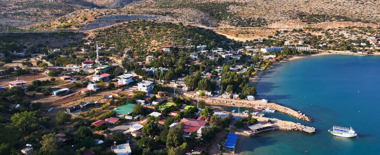
Located in the Silifke district of Mersin, Eğribük Bay is also known as Barbaros Bay. Situated 3 kilometers inland from the coastal route along the Mersin–Antalya highway, it is a hidden paradise set between two towering mountains. The fact that Eğribük Bay has remained largely untouched makes it truly remarkable. There are no commercial facilities in the area, only a small number of homes belonging to local residents.
These residents offer simple services such as gözleme (stuffed flatbread), tea, and coffee, though they may not be able to meet all needs. The trail, surrounded by shades of blue and green at every step, provides a memorable experience and stretches for 13.12 km with a moderate level of difficulty. At the endpoint, Mavikent, there is a market or snack bar available, and the area is also suitable for camping.
Mavikent– Tisan (Cilicia Aphrodisias)
The hiking route starts in the Mavikent area, opposite Dana Island, with pine forests on one side and the striking colors of the Mediterranean Sea accompanying hikers on the other. Stretching for 8.13 km, the trail follows a relatively quiet coastal road. Those who prefer can drive along this route to connect with Stage 38. It is best suited for hiking during the spring and autumn months.
Tisan Peninsula (Aphrodisias)
The trail stretches across the peninsula where the ancient city of Aphrodisias is located, winding from one end to the other. Along the way, hikers are accompanied by the blue, indigo, and turquoise shades of the Mediterranean Sea, with the route occasionally passing through forested areas. Although the ancient city of Aphrodisias, spread across the peninsula and its surroundings, remains unexcavated, a considerable part of the hike follows the impressive city walls and towers dating back to the 5th or 4th century BC. The trail is and of
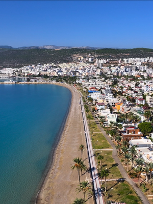
With its snow-white sands and turquoise waters, the Tisan Peninsula resembles a coral cove. It is said that this remarkable bay, where blue and green meet, was discovered by a colonel flying over the area in a helicopter during the Cyprus Peace Operation. Later, together with friends who explored the region, the colonel established the Tisan Construction Cooperative, which built a resort in 1976; the peninsula, now a popular holiday destination, takes its name from this cooperative.
The peninsula features two bays—one to the east and one to the west—both known for their white sands and turquoise waters. Opposite the eastern bay, within swimming distance, lie two small islands. The area attracts attention not only for its natural beauty but also for its historical remains. According to some sources, its history dates back to Aphrodisias, a Greek colony founded in the 7th century BC. In this context, the Tisan region is considered a historical site where the ancient settlement of Aphrodisias—meaning “dedicated to the goddess Aphrodite” (also referred to as Cilician Aphrodisias to distinguish it from the site in Aydın)—was located.
The path is easy and is best suited for hiking in the spring and autumn months. Markets, guesthouses, and restaurants are available at both the starting and ending points of the route.